Topography:
On topographic feature, the municipality of Naga is generally hilly in character. It is 90% hilly and 10% lowland. Its elevation ranges from 20 feet above sea level which in the flattest point and about 100-300 feet above sea level being the extreme. The slope pattern is rolling with slopes varying from 1.00% in the lowland to about 25.00% in the mountainous part.
Climate:
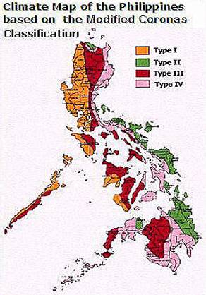
The climatographical map from PAG-ASA shows that the climate of the municipality of Naga is of the fourth type wherein by the nature of its geographicallocation and its wide and extensive area, it experience different climatic condition. The southern part is relatively dry from November to May and wet duringthe rest of the year. Its rainfall is evenly distributed throughout the year. Thistype is however, typical and common to the rest of the provinces and localitiesin Western Mindanao. Average annual rainfall for the municipality is 194.70millimeters. Temperature is fairly warm throughout the year. Due to lack of dryseason, the relative humidity from January to May is 80% and 85% from Juneto December. As maybe observed, the highest values occur during wet months.Prevailing wind direction is southwesterly. The occurrence of typhoons in themunicipality is unheard of. The winds experiences in the area are merely theresults of depressions and monsoon winds.
AVERAGE MONTHLY RAINFUL, TEMPERATURE, HUMIDITY, DEW POINT, MEAN CLOUDNESS
|
|
JAN |
FEB |
MAR |
APR |
MAY |
JUNE |
JULY |
AUG |
SEPT |
OCT |
NOV |
DEC |
AVE. YEARLY |
|
RAINFALL (mm) |
100 |
100 |
100 |
100 |
236.40 |
250 |
250 |
250 |
250 |
250 |
250 |
200 |
194.70 |
|
MEAN TEMPERATURE (ºC) |
26 |
26 |
26.5 |
27.5 |
27.5 |
26.5 |
27 |
26 |
26 |
26.5 |
26.5 |
26.2 |
26.54 ºC |
|
MEAN RELATIVE HUMIDY (%) |
80 |
80 |
80 |
80 |
80 |
85 |
85 |
85 |
85 |
85 |
85 |
85 |
83% |
|
MEAN DEW POINT (ºC) |
22 |
22 |
22 |
24 |
23 |
23 |
23 |
23 |
23 |
23 |
23 |
23 |
23 ºC |
|
MEAN CLOUDNESS(%SKY) |
7 |
7 |
6 |
7 |
6 |
7 |
7 |
8 |
7 |
7 |
7 |
7 |
7% SKY |
SOURCE: PAG-ASA, 1980